(PDF file)
(PDF file; 3.9 Meg)
(PDF; 0.3 Meg)
(1988) Co-authored with Marie Agnes Bertaud and James O. Wright (PDF 6.5 Meg)
(ABDCE Conference April 2002) (PDF 3.5 Meg)
“(Princeton, April 9, 2003) (PowerPoint 3 Meg)
(Ciudad deMexico, 3 de Julio 2003, PowerPoint 3.5 Meg)
coauthored with Jan K. Brueckner, (April 2003) (PDF, 0.5 Meg)
Architectura y Urbanismo, Brazil , # 225 December 2012 issue,(PDF 4 meg)
World Bank’s Sixth Urban Research and Knowledge Symposium, October 2012 (PDF 1.3 MB)
Planning Course for Chinese Urban Planners
prepared for China National School of Administration (CNSA) and the World Bank Institute (2003)
(Vienna, UNESCO Conference, May 2005,)
Spatial Tools to Analyze the Impact of Land Markets on Affordability and Urban Spatial Structures
(World Bank, Washington DC , Feb 2008)
(April 2001) (PDF 2.3 Meg)
El Papel de los Urbanistas en una Economía de Mercado Panama, Marzo 10-13 2003 (Powerpoint 9.00 Meg)
(Marikina, May 2003, PowerPoint 8 Meg)
coauthored with Stephen Malpezzi (December 17, 2003, PDF 2.0 Meg)
Pretoria, South Africa, April 10 2008. (PPT 6 Meg)
(January 2005, PDF 5 Meg)
(PDF 3.9 Meg)
(PDF 0.6 Meg)
( July 19 2006, PDF 3 Meg)
(Beijing, July 2007, PPT 3 Meg)
(CPN Urban Congress, Beijing, July 14-15, 2008, PPT )
China: 低价住房的供给及相关政策 – 北京? 2007年7月19日 (Housing Affordability, Chinese version)
( August 2007, PDF 4 meg)
Beijing, July 2009 (PDF 3 meg)
(January 2003, PDF 5 Meg)
(Word file, 0.2 Meg)
(revised 2011, PDF file 0. 6 Meg)
(Mumbai, April 3 2008, Pdf 7Meg)
(Mumbai, April 7, 2003) (PowerPoint 1.3 Meg)
(PDF file, 2.1 Meg)
( Word File 1 Meg)
( 1992, PDF, 1.3Meg)
(2012, PDF, 5 MB)
(Dec 2002) (PDF 0.5 Meg)
(May 2010, Brookings Institute) (PDF, 2 Meg)
(March 2011, PDF , 3 Meg)
(June 2011, PDF)
(Pretoria, Nov 2008, PPT 6 Meg)
(Pretoria, Nov 2009, PDF 3 me)
17.–19. June 2004
(University of Illinois, Urbana, June 2004, PDF 0.5 meg)
(Dec 2000) Co-authored with Marie Agnes Bertaud (PDF 1.6 Meg)
(PDF; 6 Meg)
Co-authored with Bertrand Renaud – World Bank working paper (PDF; 0.3 Meg)
(pdf 1.1 meg)
(PDF; 4.5 Meg)
(Jan 1999) (PDF 5 Meg)
Coauthored with Marie-Agnes Bertaud (Jan 2002) (PDF 0.5 Meg)
June 2006 (PDF 2 Meg)
(PDF file, 3.6 Meg)
(PDF 1.3 Meg)
“Sprawl and urban spatial structures: growing pains or real issue?”
(PPT 28 meg, Princeton, Dec 15 2005)
(PDF 3 Meg)
Land use and financial models are used to test the feasibility of large land development projects. They can also be used to test the affordability of land use regulations. They allow trade off between many different parameters, land use, land use intensity (FAR), rate of interest, scheduling of works. They should be used from the early design stage to completion of the project. They should not be used after design is completed but in parallel with design. A number of models used in real projects in real cities are presented here. Each model is different from the other reflecting the different issues faced by the land development project.
(Moscow, Jan 1994, PDF 3 Meg)
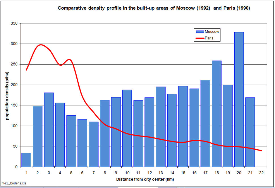
The profile of urban built-up densities may reveal the economic past history of a city
This graph shows the difference in a city’s spatial structure between Moscow that was “designed” by a central planning organization and Paris that was shaped mostly by market forces. Although densities are lower in Paris than in Moscow, commuting distance are much higher in Moscow because of the differences in the density profile (most people are farther away from the center in Moscow than in Paris).
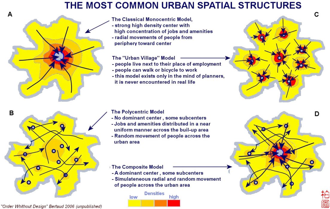
The pattern of commuting trips shows how the labor market works in different spatial structures
–
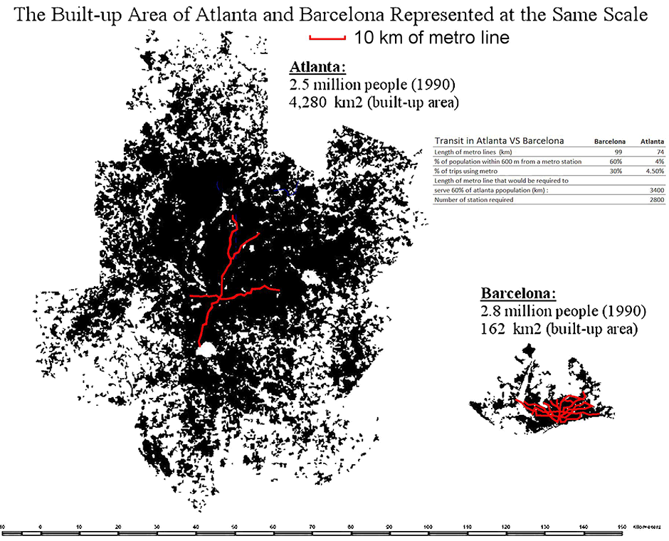
Urban densities are not trivial, they severely limit the transport mode choice and change only very slowly
Because of the large differences in densities between Atlanta and Barcelona about the same length of metro line is accessible to 60% of the population in Barcelona but only 4% in Atlanta. The low density of Atlanta render this city improper for rail transit.
Designing and tracing new streets on the ground in fast growing cities is the main task of urban planners
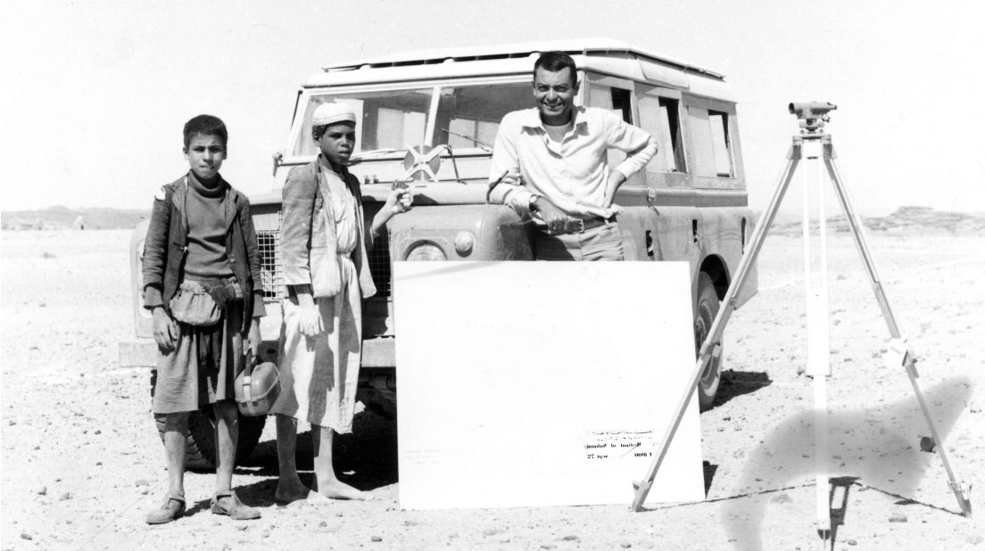
In Yemen in 1972, Alain Bertaud and two assistants surveyors tracing new streets for the expansion of Saada, in the north of the country.